Unlike land mammals or coastal species that tend to stick to familiar areas, manta rays are hard to track. Pelagic/oceanic manta rays, the largest manta ray species, travel long distances across the open ocean; reef manta rays and the newly identified Atlantic mantas stay closer to home but still cover wider areas. Either way, if we want to protect the gentle giants of the ocean, we have to track where they go, when, and why.
The tools (and challenges) of manta tracking
There’s no single method to follow a manta ray’s movements. Most research projects rely on a mix of techniques to gather information.
Photo-ID (belly pattern identification)
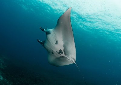
The most widely used and least invasive method is photo identification. Every manta ray has a unique spot pattern on its underside, like a fingerprint. Scientists can recognize individual manta rays by comparing belly photos taken during snorkel tours, research dives, or casual encounters.
One limitation of this method is that photos can only be taken where snorkelers and divers can go, usually shallow reefs. As a result, we know a lot more about the behavior and movements of reef manta rays than about the pelagic and Atlantic manta rays, who spend more time in open waters.
Satellite tags
Satellite tags are small tracking devices that researchers attach to the manta’s body, often just behind the dorsal fin. These tags transmit data to satellites whenever the manta ray reaches the surface.
The tags are expensive and usually detach after a few weeks or months, so the window for data collection is limited. In some cases, location data can be patchy or imprecise, especially if the manta doesn’t surface often or if the tag’s signal is weak. Still, satellite tags remain one of the few methods to monitor long-distance travel, particularly for the manta species that cross open oceans.
For example, in 2019, researchers from NOAA Fisheries and the Marine Megafauna Foundation attached a satellite tag to a young male manta ray named Leo off the coast of Florida. They were able to consistently gather high-resolution data on his location, diving depth, and surrounding water temperature for over a month. This helped them understand how environmental factors like temperature or ocean currents may influence where manta rays travel.
Another study conducted by researchers from the University of Auckland used a satellite tag to track a pelagic manta ray for six months during the summer of 2021. This showed that as summer ended in New Zealand, the manta made the long trip to warmer tropical waters near southern Fiji.
Acoustic tags
Unlike satellite tags, acoustic tags don’t rely on surface transmission. Instead, they send out a short-range signal that can be picked up by underwater receivers placed in known locations. Every time the manta swims near one of these listening stations, it gets logged.
These tags are generally smaller and less costly than satellite tags. They last for months or even years, but only collect data in places where receivers are installed, so they work best for reef manta rays that tend to stay in familiar spots.
That doesn’t mean the method can’t work for pelagic manta rays; between 2015 and 2021, scientists in Mexico tagged 66 pelagic manta rays in Bahía de Banderas, a coastal bay where this species gathers in large numbers. Using acoustic tags and a network of underwater receivers, the scientists tracked manta activity in the area for up to 300 days per individual, making this one of the longest-running acoustic tagging studies for manta rays to date.
The study revealed that pelagic manta rays visit the bay most often between January and March and May and October. Their presence was linked to certain ocean conditions, like water temperatures between 25°C and 29°C, higher plankton levels, and specific wind patterns. Mantas were primarily detected in the mornings, suggesting they may dive deeper at night.
This long-term data helps researchers better understand how environmental changes and human activity might affect manta rays in coastal areas like Bahía de Banderas.
Drones
In recent years, drones have become a more common tool for manta ray research, especially in areas with clear water and regular manta activity near the surface. Researchers can fly drones above the coastline to observe when manta rays are feeding, interacting with one another, or traveling.
Drones are best for short-range observation. They’re typically flown in circles or set to follow a specific manta for a limited time, giving researchers a bird’s-eye view without disturbing the animals.
A study in West Papua showed how useful this method can be. Researchers monitored a population of reef mantas with drones and were able to document their behaviors, including group feeding and courtship trains (when several males follow a female in hopes of mating). The drone footage also helped identify individual manta rays using their markings, much like traditional photo-ID methods, but with a new perspective from above.
Unlike tags, drones aren’t used for long-term tracking; instead, they give scientists a real-time look at manta behavior in the wild. This is a great complement to tagging and photo-ID work, and it helps to find out details about manta behavior that tags alone can’t capture.
Notes, logs, and sightings
This old-school method is still highly valuable: divers, snorkelers, and tour guides write down what they see. Especially when paired with photos or video, these human observations continue to fill in critical gaps between high-tech data points.
How we track the reef mantas of Kona
At Manta Ray Advocates, we’ve been documenting individual manta rays along the Kona coast for decades. Every time we go out on a manta ray moonlight swim, or even back when we got hired as an underwater camera crew, we’ve taken note of which manta rays show up. We recognize them by the unique spot patterns on their bellies, and over time, we’ve come to know many of them as individuals.
We keep a record of each sighting, including when and where the manta was seen and any notable details, such as if they were injured, pregnant, or traveling with a group. We also add updated photos and videos when possible. All of this is logged in our Manta Ray Library, which tracks the lives of Kona’s reef mantas over time.
→ Visit our manta ray library here
What we’ve learned from tracking reef mantas
Thanks to decades of research worldwide, scientists have been able to map out how (reef) manta rays move.
Reef mantas tend to return to familiar places over and over again. Cleaning stations, feeding areas, and sheltered bays are common hotspots; knowing this makes it possible to track individuals over time.
Reef manta rays tend to stick to certain coastal regions and form distinct local populations. For example, the manta rays seen along the Kona Coast on the Big Island are different individuals from those spotted around Maui (a different Hawaiian island). These populations don’t seem to mix, even though the islands aren’t far apart. This shows why monitoring animals locally is important: what happens in one area might not reflect what’s going on elsewhere.
Tracking has also helped scientists uncover how manta rays respond to changing ocean conditions. Water temperature, tides, plankton blooms, and even large-scale climate events like El Niño can influence when and where manta rays appear. Some show up like clockwork during certain seasons, while others respond more to the availability of food or to water quality.
Why tracking manta rays is important
By tracking where mantas spend their time, scientists and conservationists can identify significant locations like cleaning stations, mating grounds, or feeding zones, and assess which habitats are most critical to the survival of these gentle giants.
That knowledge can then guide more effective conservation efforts:
- Authorities can create or expand marine protected areas to include the zones manta rays rely on most.
- Policymakers can introduce tourism guidelines that help reduce stress on the animals.
- Fishing boats can avoid certain areas or use safer gear to prevent manta rays from getting caught by accident.
Tracking data also helps create rules that protect manta rays. It gives conservation groups strong proof to ask for local protections and supports worldwide efforts to keep manta rays safe.
Be a part of the research: submit manta pictures!
The great thing about manta ray tracking is that you don’t have to be a marine biologist to help. In fact, many of the most important sightings come from regular people who just happened to be in the right place with a decent camera. A belly photo submitted to a local database can confirm a manta’s identity, tell us about its range, or even reveal new behavior.
If you’ve had the chance to swim with manta rays and caught a good snapshot of their belly patterns, you can help researchers by adding your pictures to these databases. These sites collect photos from all over the world to track individual manta rays and learn more about them.
MantaMatcher (global)
Manta Matcher is a free, global database where anyone can upload photos of manta rays’ belly patterns. When you submit a photo, a local researcher reviews the information to make sure it’s accurate, so you don’t need to worry if you’re unsure about the species or other details. Then, the system compares your photo to thousands of others to find a match or identify a new individual.
It’s a great tool for both citizen scientists and researchers because it aggregates manta sightings from all over the world.
→ Go to MantaMatcher Database here
Manta Trust’s MantaBase (global)
MantaBase collects photos and sighting reports globally, focusing on long-term monitoring. You can submit your photos and details of your sighting through their website, and researchers use the data to understand manta ray populations, migration, and behavior. It’s a community-driven project that combines tourist and scientist contributions.
→ Check out Manta Trust’s MantaBase here
Kona Manta Ray Library (Big Island of Hawaii)
If you’ve seen a manta ray off the coast of Kona and got a clear photo of its underside, we encourage you to look it up in the library and leave a comment. Your photo might confirm a re-sighting, help us understand patterns, or even document a brand-new individual.
Thanks to contributions like these, we’ve been able to identify dozens of previously undocumented manta rays. When we confirm a new one, we get to name it and try to do that with a good dose of humor.
→ You can access the Manta Rays of Kona Library here
→ Don’t know which manta you caught on camera? Send us the picture and we’ll help!
Project Manta: University of the Sunshine Coast (Eastern Australia)
Project Manta is a collaborative research program based at the University of the Sunshine Coast in Queensland, Australia. Established in 2007, it aims to investigate the population biology and ecology of manta rays in eastern Australia. The project relies heavily on contributions from citizen scientists, divers, snorkelers, and other water users, who submit photographs, videos, and observations of manta rays to the Project Manta database.
One of the most famous mantas in Eastern Australia is Taurus, first spotted off Lady Elliot Island back in 1982. He was already a mature male at the time. Since Project Manta began tracking him in 2009, they’ve recorded over 50 sightings of Taurus, all around Lady Elliot Island. He’s estimated to be at least 50 years old!


0 Comments